
Updated October 2025
Easter Island, known as Rapa Nui in the native language, frequently appears in scientific literature due to its unique significance for anthropologists. As an extremely isolated location, it offers immense potential for studying the colonization, cultural development, and eventual decline (?) of its indigenous population, as well as its ecological history. Having visited this remarkable place myself, I find special satisfaction in writing about it..
A bit of history, in chronological order
- 3 million years ago (Ma) the Poike volcano erupted and created a conic island. The highest point is 370 m.
- 2.5 Ma the Rano Kau volcano erupted and created another corner of the island. The highest point is 300 m.
- 0.3 Ma the Terevaka erupted and created the highest point of Easter Island, with 511 m.
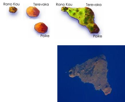
- Those three primary volcanos plus other 70 secondary volcanos and the natural erosion created the triangular form the island has today, with 173 km2.
- It is one of the most remote inhabited places around the world. The closest inhabited island is Pitcairn (nearly 2,000 km away) and it is 4,100 km away from Tahiti and 3,700 km away from the Chilean mainland.
- Between 65,000 and 30,000 years ago: modern humans colonize Australia, New Guinea and the adjacent islands until Solomon Islands.
- Between years 2000 BC-1000 AD: modern humans reach Micronesia, East Melanesia, Polynesia. Between 2000-500 BC the Lapita culture emerged, which geometric shapes expanded throughout Polynesia.
- 500 BC: the Polynesians from Tonga and Samoa went East to reach Cook Islands, Tahiti, Marquesas and Australes.
- 700 years later, 200-400 AD, Hawaii was colonized, and then Easter Island around 400 AD. According to some petroglyphs found, the colonizers likely used at least two double canoes.
- 400-800 AD: occupation of the island. This is one of the most recently populated islands. The natives called it “Te pito o te henua” (the navel of the world) and also “Mata ki te rangi” (eyes that look at the heaven). The name «Easter Island» was given by the island’s first recorded European visitor, the Dutch navigator Jacob Roggeveen who encountered it on Easter Sunday, 1722. He called it in Dutch “Paasch-Eyland”. The name Rapa Nui (“big island”) was coined later in time after the slave raids of the 1860s.
- 800-1680 AD: Ahu Moai phase, development of the typical Rapa Nui culture with 300 ritual platforms called Ahu and 900 giant statues called moai, which weigh as much as 80 metric tons.
- 1680-1850 AD: Huri Moai phase, development of the Tangata Manu (bird-man) culture.
- 1722: Roggeveen arrived to the island and estimated a population of 2,000 to 3,000.
- 1877: the slave trade and the over-exploitation of natural resources reduced the native population to only 111 (from a possible peak of 20-30,000).
Key studies on the Rapa Nui ancient population
1) When did the contact between Rapa Nui islanders and Native Americans actually happen?
In 2014, according to Moreno-Mayar et al., the genome of 27 living Rapa Nui islanders showed the presence of early Native American, suggesting the hyphotesis of a contact around 1280-1425. This could be explained by either two options: 1) Americans arrived Rapa Nui shortly after the Polynesians, or 2) Polynesians from Rapa Nui used the Pacific currents to sail to South America, they obtained sweet potatoes, bottle gourd plants and chickens, and then returned home with some South Americans also on the canoes.
In 2017 Fehren-Schmitz et al. analysed the genetic material preserved in the skeleton of 5 ancient Rapa Nui individuals. They were excavated in 1980 and preserved in the Kon-Tiki museum in Oslo, Norway. 3 of them lived before the Europeans arrived, and the other 2 after the arrival. Their genomes actually showed no presence of Native American traces, which indicates no gene flow with Americans before the arrival of the Europeans in 1722.
Again, traces of Native Americans were found in two further studies (Ioannidis et al., 2020 and Moreno-Mayar et al., 2024). The latter reveals admixture with ancient South Americans which took place soon after first landfall, about 1250–1430 CE.
2) The ecocide theory
Did a collapse of Easter Islanders happen BEFORE the Europeans arrived?
A classic version of what happened in the centuries after Polynesian seafarers colonized Easter Island is described by Jared Diamond in his book Collapse (2005):
- The rivalry between clans drove the islanders to build the increasingly big moai.
- The fierce competition and population growth caused an over-exploitation of resources, driving the people to desperation, and even cannibalism.
- Europeans arriving in the 18th century encountered a society well on its way to decline.
Did a collapse of Easter Islanders happen AFTER the Europeans arrived?
The analysis of hydrated obsidian tools and flake artifacts sampled from various separate areas has reflected that pre-European contact population and productivity declines in some near-coastal and upland areas, and post-contact increases and declines in other areas (Stevenson et al., 2015). This would explain a pre-contact overall decline in land use and food production, but argues against an island-wide pre-contact overall collapse.
3) There was actually no collapse.
According to Moreno-Mayar et al. (2024), after the admixture with ancient South Americans there was no later drop in genetic diversity consistent with an ‘ecocide’. Based on the genomes of 15 Rapa Nui islanders dated to 1670–1950 CE, through effective population size reconstructions and extensive population genetics simulations, the authors reject a scenario involving a severe population bottleneck during the 1600s, as proposed by the ecocide theory.
4) Collaboration between clans, rather than competition?
The moai were built without the help of wheels or large animals. On other side, all the stones to build the moai were coming from one quarry complex, even though there are other sites to get basalt on the island. This leads to a new hypothesis proposing that the island was not dominated by massive chiefdoms, and rather, communities interacted and shared resources without any prehistoric warfare. The clans may have had a system of exchange that allowed them to trespass on each other’s territory to share resources.
5) Moving moai
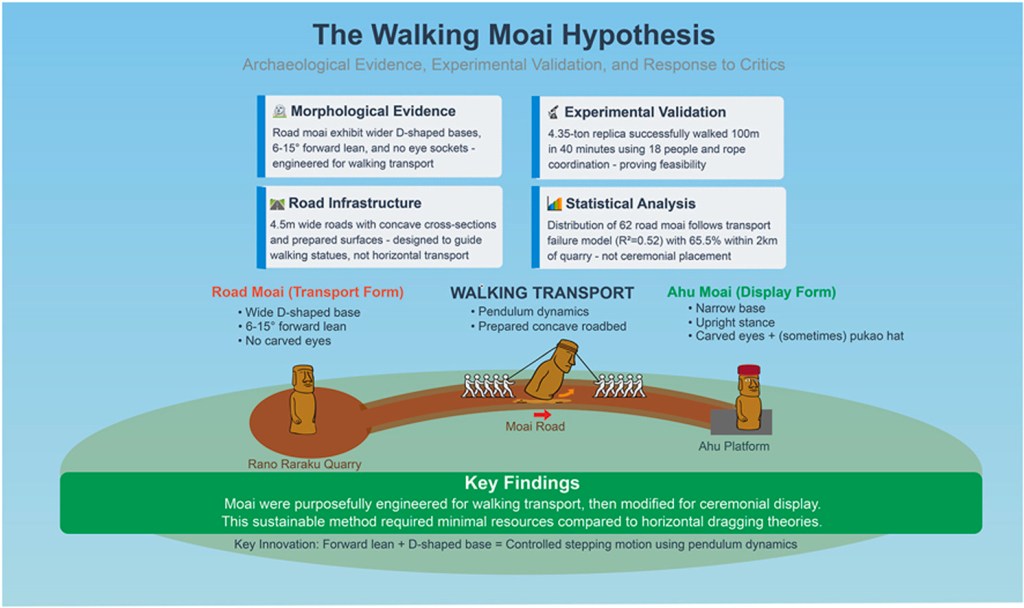
Based on a systematic analysis of 962 moai, with a focus on 62 road statues, combined with 3D modeling and experimental trials, Lipo & Hunt (2025) demonstrate that the moai were designed for transport vertically from the quarry to the costal line, in a controlled «walking» motion facilitated by their carved shapes. A short documentary by National Geographic illustrates how this transport could have been executed.
On the other hand, the digging up and study of Moai 156 in 2019 shows that it was erected inside the Rano Raraku quarry and not abandoned there. This is is against the classical thought of all moai being built at the quarry and then moved to other locations by the coast. Instead, some of them could serve for ceremonial purposes to keep the soil fertility os the site. The quarry could have been a horticultural “sweet spot”, where statue production and horticulture coexisted from 14th century AD to 19th century. Sweet potato (originating in South America) and Polynesian plant transfers were cultivated in Rano Raraku.
And finally, this is Easter Island!
Some pics of my visit to that great place, explaining the two Rapa Nui cultures: the Ahu Moai and the Tangata Manu.
Further references

New Guinea right?
Me gustaMe gusta